
By Thomas K. Pendergast
The cost of redesigning a multi-use trail next to the sewage treatment plant near Ocean Beach has increased almost four-fold from a 2018 estimate, now that the California Coastal Commission (CCC) has weighed in, forcing the San Francisco Public Utilities Commission (SFPUC) to revise its plans.
The intersection of Sloat Boulevard and the Great Highway, as well as the entrance to the San Francisco Zoo, will also be reconfigured.
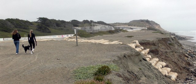
This is part of the effort to keep the sewage treatment plant from falling into the ocean.
The 2018 estimate to contract engineers for designing plans which will replace the Great Highway extension road south of Sloat Boulevard with landscaping and a “multi-use trail” (because that stretch of road has been eaten away by erosion to the point that the ocean now threatens the Oceanside Water Pollution Control Plant) was set at about $3.75 million.
In April of 2021, the contract for these engineering services was increased by $2 million for a total of $5.75 million.
After the CCC reviewed the City’s plan, however, the budget for redesigning that area swelled up to $12.75 million.
Although this appears to be a drop in the bucket for a city with a budget of more than $16 billion, nevertheless it appears to be a substantial increase for this particular project.
Nancy H. Crowley, the press secretary for the SFPUC, said amending the contract to increase the budget is necessary in order to address CCC-mandated design changes, increased design complexities related to interdepartmental shared scope elements, environmental services during construction (like inspections) and “an anticipated increase in the duration of construction of the project.
“The Coastal Development Permit requires design review and approval from the CCC staff. Therefore, we continue to work with them on the project design, and there may be additional updates and design modifications prior to construction. This amendment captures the best estimate to date,” Crowley said in an emailed response.
These changes from the original plan include eliminating a service road between the wastewater treatment plant and the Westside Pump Station.
“The CCC required the removal of the proposed service road to reduce hardscape in the coastal zone, enhance resiliency by creating as much space as possible for sea level rise adaptation, and maximize public access to the coast,” Crowley said. “We’re redesigning the Great Highway south of our (wastewater) treatment plant to make sure our vehicles can enter and exit safely. We’re also changing the access to the Westside Pump Station to allow service vehicles to enter and exit from Sloat Boulevard.”
Plus, the multi-use trail will be shifted inland to reduce the amount of hardscape in the coastal zone.
“By eliminating the service road, we’re redesigning the trail to be set back from the buried seawall as much as possible,” she said.
Because of the recent closure of the Upper Great Highway to vehicle traffic and the installation of a park over that roadway, the intersection with Sloat will also be redesigned to improve public safety for walking, cycling and driving in the area.
An additional restroom will be located in a proposed new parking lot where the service road for the wastewater treatment plant will connect with Skyline Boulevard.
There will also be a redesign of the slope stabilization layer to protect the Lake Merced Tunnel at a flatter slope for supporting dune restoration, wave run-up and “create a more resilient dune habitat.”
Plans include relocating the beach access stairs farther north to maintain safe public entry and adding five coastal overlooks along the coastal trail to give visitors places to rest and enjoy ocean views.
“These are some of the more visible changes, but as a reminder, this multi-agency project has been in development since the Ocean Beach Master Plan was adopted in 2012. Since 2015, we’ve made a number of short-term improvements, including beach nourishment activities and installation of sandbags along the southern portion of Ocean Beach fronting the Great Highway,” Crowley said.
Erosion of the beach in this area has been a problem and a risk going back to the early 1990s.
The immediate concern, however, is the Lake Merced sewage tunnel, a 14-foot-diameter pipeline that carries sewage water from the residences of the Lake Merced area to the plant, where it gets treated, cleaned and then released through another pipe going into the ocean about four miles out to sea. The Lake Merced Tunnel goes under the Great Highway along Ocean Beach, but well below the beach level. It is also the most seaward component of that facility.
Categories: SFPUC


why wasn’t there a similar review of the Crypto Tech Bros Dune Park before the Gr Hwy was closed?
LikeLike
A fair question.
LikeLike
Missed commenting on this when it was originally published. I was a community stakeholder on the 2012 Ocean Beach Master Plan (OBMP). Many of these “changes” adding to the cost of the erosion project were elements we recommended in the Ocean Beach Master Planning process. What happened? The studies and permitting phase took nearly 10 years. Funds for keeping the OBMP stakeholder meetings going ran out. It appears SFPUC may have forgot the importance of key goals such as: habitat restoration of a dune backed shoreline (btw – the real reason for the road closure retreat), a proper setback for the recreational trail (to avoid damage from storm surf) – and restoration of public parking for beach access which would include a restroom and shower. The concrete staircase to the beach was never included in the OBMP. That, combined with their newly updated, conventional seawall could mean trouble for safe access to the water.
LikeLike