
By Thomas K. Pendergast
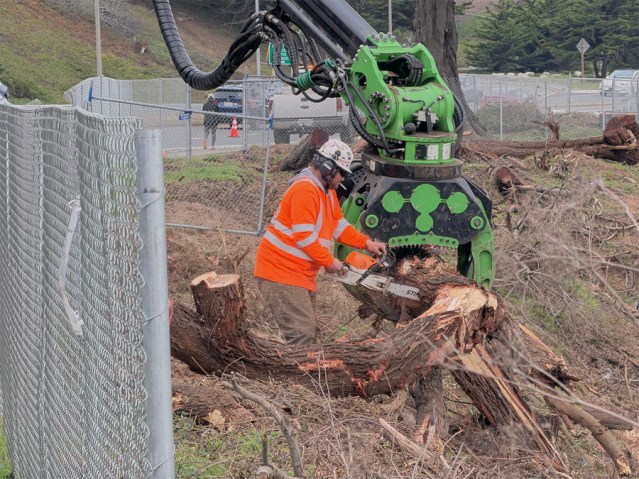
Workers are cutting down more than 800 trees around Lake Merced as part of larger ongoing projects to remove species not native to the area and revamp the watershed to help it drain into the lake.
The trees being cropped are primarily Bluegum Eucalyptus, Monterey cypress, Myoporum laetum and blackwood acacia.
The eucalyptus are particularly problematic and so more than 200 of the total being cropped are those trees.
Initially brought to California by Australians during the Gold Rush era, their use was greatly expanded in the 1880s by the Army – along with Monterey Cypress and Pine trees which are native to California’s central coast – to conceal and beautify harbor defenses, according to the National Park Service.
At the time, San Francisco had native trees like the California Buckeye and Oaks but most of this area was relatively barren grasslands and scrubland, while Redwoods were not popular for use as lumber. So, anticipating a need for more trees to build houses, the eucalyptus trees were promoted for use as lumber. But this proved to be wrong because they tend to crack when dry and grow in a twisted way that makes it less than ideal for planks.
The habitat around the lake will be replanted with native arroyo willow trees and other wetland shrubs from western North America, including freshwater marsh plants and coastal dune scrub bush.
On the western bank of the south lake there is also an erosion problem encroaching on Skyline Boulevard just north of the SFPD shooting range that needs attention.
The arroyo willows, coastal scrub and a variety of marsh plants will mostly be planted at the lower elevations near the banks and shoreline of Lake Merced.
This is part of a much larger project, which includes neighboring Daly City, called the Vista Grande Drainage Basin Improvement Project.
The lead agency who will be in charge of culling the trees for this project is Daly City’s Department of Water and Wastewater Resources. That department’s Director, Joshua Cosgrove, said other agencies involved include the San Francisco Public Utilities Commission (SFPUC), San Mateo County and the State of California through the California Department of Transportation (Caltrans) and the California Coastal Commission.
Along with other trees set for removal, the eucalyptus will be coming down because they are considered an invasive species, plus as time goes by it is expected that they will become more dangerous.
“So they were identified as being removed because of that but they’re also quite old and they’re at that age where they become a hazard,” Cosgrove explained. “The team has ecologists and environmentalists that identified the different trees that were non-native, invasive and a hazard. And as we’ve gotten out there, we’ve identified a few more also.”
Plus the California Coastal Commission has also weighed in on this project.
“They have their own ecologists,” he said. “When they issued our permit … they said ‘this is what we are looking to have you do.’
“We have extensive studies on all that, on why we’re removing what we’re removing. It’s our requirement through the California Coastal Commission.”
The Vista Grande watershed area is located in Daly City and unincorporated Broadmoor Village, in northwestern San Mateo County.
The watershed is approximately 2.5 square miles in area and is bordered by San Francisco County to the north, Colma Creek watershed to the south and east, and the Pacific Ocean on the west.
It is drained through the Vista Grande Canal and Tunnel (first built in the1890s) which are located in San Francisco, adjacent to John Muir Drive and the southwestern shoreline of Lake Merced. The tunnel outfall is located at the Pacific Ocean and Fort Funston.
Daly City officials say the existing canal and tunnel do not have adequate hydraulic capacity to handle peak storm flows, so flooding periodically occurs in adjacent low-lying residential areas and along John Muir Drive. It is hoped that expanding the tunnel will alleviate flooding and protect the ocean outfall from ongoing coastal erosion, while reconnecting a significant
portion of the Lake Merced Watershed and also providing more water to the lake for mitigating the groundwater pumping in that area.
Fencing will be installed for sediment and erosion control, as well as irrigation systems to support new vegetation, while also applying erosion control measures like hydro-seeding and mulch.
This project will divert some storm water to the south lake to aid the SFPUC in operating Lake Merced within desired water levels.
The water level of Lake Merced has fluctuated historically from an Elevation of 13 feet in the 1940s to a low of 3.2 feet in 1993. Since then, the water surface elevation of Lake Merced has risen due to increases in average rainfall and water additions by the SFPUC.
From 2006 to 2010, the lake level surface ranged from 4.8 feet up to 6.9 feet, with an average of 5.8 feet above sea level.
The SFPUC’s overall goal is to restore historic water levels in the lake to serve beneficial uses and provide a reliable emergency water supply for firefighting and sanitation purposes. The SFPUC has identified a preliminary target range of 5.5 up to 9.5 feet of the lake water surface above sea level.
Editor’s Note: Jan. 8, 2026, 2:15 p.m.: This story has been updated to correctly identify that Daly City’s Department of Water and Wastewater Resources is in charge of cropping the trees, not the San Francisco Recreation and Parks Department. The Sunset Beacon regrets the error.
Categories: Environment


Beatify? Int’s that a process by which the Roman Catholic Church bestows saint status?
LikeLike
Fixed! Changed to beautify. Thanks for the edit.
LikeLike